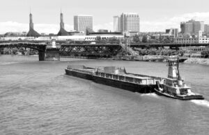
The BargeOps development team is constantly adding new features to the already robust software package. The newest feature is called BargeOps Boat Map. “Mapping boats is a feature we’ve been working on for a while, but we wanted to do it right,” said VP of Business Development, Steve Lemmon. “A customer challenged us to develop a feature that could deliver a high-level view of his boats across the river system. We delivered on that request and added much more.”
Not only does Boat Map provide a geographic mapped location, customers can now view what’s in tow with a list of barges and their contents. “Companies who’ve invested in BargeOps Onboard together with GPS technology, will see their assets in near real-time,” said BargeOps Architect, Kevin Hartman. “It really enhances the ability of a manager to see the full picture of the operation.”
For more information on this feature or the BargeOps software package, or to schedule a demo of Boat Map, please visit our DEMO page.